We now have the VMIgreenlight website running where you can track us during our training and eventually during the West to East Coast to Coast challenge by clicking on this link:
www.vmiweb.co.uk/challenge
Friday, March 28, 2008
Wednesday, March 26, 2008
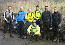
South West half of the Team in Cheddar Gorge for Easter
The South West half of the team made the most of the wind and snow on the bank holiday with a trip to one of Somerset’s finest tourist destinations, Cheddar Gorge. With its spectacular cliffs, hills and cave networks it really is quite spectacular. Starting from the bottom of the gorge the ride began with a serious hill climb which got everyone’s heart and lungs going, followed by another easier climb alongside a very picturesque small stream on a woodland trail(CIMG2702, 2703 & 2705) which took us to the summit of our first hill and was followed by a very long rewarding, rocky descent in to Cheddar itself.
Once out of the village we began the climb back up. As we approached the summit we really began to feel the effects of the very strong wind that was whistling over the top of the Mendip hills. A fairly long plod across the top of the hills and we approached our final ascent which would take us to the top of Beacon Batch, the highest point in the Mendip Hills.

A spectacular end to one of the best routes we’ve done to date. Well chosen Mr Badman!
Justin
Once out of the village we began the climb back up. As we approached the summit we really began to feel the effects of the very strong wind that was whistling over the top of the Mendip hills. A fairly long plod across the top of the hills and we approached our final ascent which would take us to the top of Beacon Batch, the highest point in the Mendip Hills.

A quick photo opportunity there(CIMG2709.jpg) and a chance to admire the view and then we had the long flowing descent down the side of the hill and then on to the road that winds its way through the gorge itself. 


A spectacular end to one of the best routes we’ve done to date. Well chosen Mr Badman!
Justin
Please do not forget to sponsor us by clicking on the JustGiving link on the left hand side and a big thank you to those of you who have sponsored us already, or go direct to http://www.justgiving.com/mplc2c
Tuesday, March 25, 2008
Easter Monday in Dalby Forest
We just can't get bored returning to Dalby Forest. Even though the red route is only 23 miles it is a long and hard 23 miles that gives us some damn good physical training that we require, so 4 of us, Peter, Adam, Elliot and I arrived at the Forestry commission car park in Dalby Forest at 10:30 to start out on the route.
The day was cold, very cold, but after the first difficult climb we would soon warm up, however what added to the difficulty was the mud. The tracks had a covering of mud from the melting snow in the gorgeous sun that just made it that little bit harder, something which I don't think we had factored in.
But with the blue skies and sun in our faces we knew we were in for a good day weather wise, well at least that's what we thought, until half way through the ride when the skies turned grey and across came the most painful wind driven hail and snow. Fortunately for us it didn't last too long and didn't hamper or spoil the ride. Not until Pete's chain broke again that is. Yes the same chain that broke whilst out on the moors! However with only a mile and a half to go, mostly downhill we free wheeled back to the cars after a long, hard but fun day.
Please do not forget to sponsor us by clicking on the JustGiving link on the left hand side and a big thank you to those of you who have sponsored us already, or go direct to http://www.justgiving.com/mplc2c
Friday, March 21, 2008
North Yorkshire Moors - Fylindales Loop 15th March 2008
Ok, so this route was a bit adventurous considering the time of year and the quantity of rainfall we have had recently, however there were still 3 of us Pete, Elliot and myself) out of the team that were stupid enough and available to give it a go as we needed the long distance training. If you google the 36 mile route you will find information about the route with the following description:


Not a route for the unifit, the unskilled or the easily lost. If that doesn't put you off, there's plenty to keep you busy for a full day; miles of moorland singletrack, forested areas and some fairly boggy fields, peppered with some lung busting climbs and some pretty full-on descents. There's plenty of rocky, technical stuff which will test your skills, pretty views to stop for, as well as some fast swooping singletrack to get you moving again.
What it should also say is that if it has rained in the last 2 weeks the tracks you need to follow will be almost invisible, the mud will be like superglue, and the heather, in between the bogs, will be as high as your waist!
So, after leaving the cars in a quiet forest we headed off down a very well kept fire track through the forest for about ten minutes. Then we turned off the firetrack onto a sparsely used track and this was where we hit the first mud section. To be honest at this stage it was quite funny as we all took it in turns in sliding to a muddy end on the floor without any control over the bikes because of the deep, thick gue we were attempting to navigate through.
Once out of the mud we broke out onto the moors, now starting to realise that this was a very bleak and potentially inhospitable place to be caught out if something went wrong, but we were confident. Well I was because I was the one carrying the map!

However Peter had no faith in my navigational skills and was adamant we had gone wrong so he had us cross the river, climb an embankment carry the bikes for about half a mile through bog before deciding that this might not have been one of his best ideas and that we should cross back again. So we did. Through the bog, down an embankment, through the river and into some of the highest heather I have ever seen. Waist high snow would have been easier, but we persevered. (how foolish!)

There was light at the end of the tunnel though as we could just make out, a few hundred yards away, a trail cutting its way through this very remote part of the Moors. It was probably an hour before we reached the track and at least two hours since I had last ridden my bike (I can't ride through bog, rivers and thigh high heather!) but we finally made it to the track. What a relief. But oh no the track was not a track but a thick, shallow river of molten mud. Not deep but thick like we had never seen before and wherever the mud touched it stayed. The bikes became clogged beyond belief with mud until my rear gear mech gave up the ghost and destructed itself and Pete's chain managed to wrap itself (mud assisted of course) around the crank..... twice.
With repairs made but with two very sick bikes (I had one gear and Pete had a chain that would eventually break 10 minutes later) we decided to head for the cars, hmmmm I wonder where they might be???!
We did made it back and were very relieved to see the cars but with bikes that would need some remedial work after a ride (and bike carry) that started at 10:01 and finished at 15:06.
Please don't let me pick any more training routes!
Please do not forget to sponsor us by clicking on the JustGiving link on the left hand side and a big thank you to those of you who have sponsored us already.
Saturday, March 8, 2008


Dalby Forest Training 8th March 2008

On Saturday morning Elliot, Adam and I set off from Leeds for Dalby Forest in the Yorkshire National Park to try their Red Route without the snow that we had encountered last month. That was after we'd had the compulsory bacon butty at the Forest cafe. On the website it interestingly states about the Red Route "Ensure you and your bike are ready for several hours of hard, technical riding" which was not far from the truth at all. The technical sections included board walks, rock paths bizzare bridges, bermed corners, bomb holes and steep switchbacks to name but a few that tested our brakes, full suspension or seat padding, our agility (or rather lack of it!) and concentration, to their full.
And then included in the middle of the forest is a circuit for those of us that might want to catch some 'air'!
But all in all an excellent 25 mile ride with some excellent skill testing sections.
Please do not forget to sponsor us by clicking on the JustGiving link on the left hand side and a big thank you to those of you who have sponsored us already.
Some route statistics:
Total Ascent: 2431.1 ft
Total Descent: 1998.0 ft
Maximum Elevation: 859.6 ft
Minimum Elevation: -137.8 ft

Monday, March 3, 2008
St Bees to Robin Hoods Bay recce

Preparation day: 19th May 2008
Our Coast to Coast mountain bike route of 210 miles is across some pretty arduous terrain and we can only best average between 40 to 50 miles a day so we need 5 places to stay, not including the preparation night at St Bees.
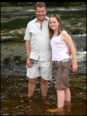
So Marc, Justin and I set out to recce the route and to find some places to stay, places that wouldn't resemble a sheep trough (we nearly booked one of those!) and cheaper than the Plaza and this is what we came up with. But once at St Bees we couldn't resist a ride across some of the spectacular coast line from St Bees to the Light House!
St Bees is famous as being a start point for Coast to Coast treckers but ones usually doing it on foot
 however with some temporary changes made you can see from the photo that this will also be our start point for the ride.
At St Bees we will be staying at Seacote Park for our preparation night of 19th May 08. More information on the park can be found at: http://www.seacote.com/
Click here for a weather update: http://www.bbc.co.uk/weather/5day.shtml?id=1403
Day 1: 20th May 2008
Once we leave St Bees we have a long trek before our first overnight stop at Scarr Head Farm, Torver which is a hamlet very close to Coniston Water, famous for the Land Speed Record attempt by Donald Campbell and for the spectacular countryside which can be seen at:http://www.thelakedistrictwalker.com/valleys/south/torver.htm
Click here for a weather update: http://www.bbc.co.uk/weather/5day.shtml?id=2451
Day 2: 21st May 2008
As we follow the trail heading East across the Lake District, up fell, past tarn and down hills across Cumbria, our next overnight stop will take us to the Pennine View Caravan and Camping Park in the picturesque town of Kirkby Steven. The following is an extract taken from their website:
Kirkby Stephen is a small town in the Upper Eden valley which was formerly in the old county of Westmorland, now Cumbria. This is an area of Cumbria much less well known than the Lake District, but equally appealing. A traditional market town of historic buildings, cobbled yards, quaint corners and interesting shops, it is surrounded by a landscape of pastoral rural scenery and wild uplands. Being remote from large towns and population centres, Kirkby Stephen has developed a strong and self-sufficient identity and a vibrant sense of community.
More details of the campsite can be found at: http://www.coasttocoastguides.co.uk/accommodation/pennine%20view/index.htm
Click here for a weather update: http://www.bbc.co.uk/weather/5day.shtml?id=1392
Day 3: 22nd May 2008 On our 4th day we will leave the Lakes, cross the pennines (this is making my legs ache thinking about this!) and arrive in Brompton on Swale in the heart of the North Yorkshire countryside and at the gateway to the Yorkshire Dales. The camping and caravan park at Brompton on Swale set next to the river Swale is just a couple of miles from Richmond. More information can be found at: http://www.bromptoncaravanpark.co.uk/ Click here for a weather update: http://www.bbc.co.uk/weather/5day.shtml?id=1683
Day 4: 23rd May 2008
This day takes us through the Yorkshire Moors towards our ultimate goal of reaching what will have seemed an impossible sight of the East coast, but before we get there we have one more overnight stop at a campsite/farm/toilet in a field with a gate on called Hollins Farm in Glaisdale.

Run by a little ol' lady this campsite really is what this challenge is all about; remote but
beautiful, arduous but rewarding. Sorry guys, there are definitely no jacuzzis at this site, but if we manage to arrive before 18:30 the local taxi will come and pick us up and take us to the only pub within a sensible radius where we can be fed. We have to be picked up before 18:30 as the taxi driver is the pub landlord and chef!
Click here for a weather update: http://www.bbc.co.uk/weather/5day.shtml?id=3965
Day 5: 24th May
From Glaisdale we will be on our final leg (or should I say legs!) to end in the sea at Robin Hoods Bay. Children and sandcastles please be aware because I think by the time we arrive at Robin Hoods Bay after crossing the remainder of the Yorkshire Moors we won't be in much fit state to ride carefully. However the ride into Robin Hoods Bay will only be 26 miles long so anyone will be welcome to join in. Once our celebrations have died down on the beach (we expect to arrive early afternoon) we will head to our last stop, by vehicle I hasten to add, but this time with our families and friends to a beautiful family run caravan and camping site at Fylindales, just 4 miles from Robin Hoods Bay. It has good amenities and has been updated recently which cannot be seen from its website which does it no justice. This will be a fantastic time for us all to get together and look back over the previous week (providing we make it!) and celebrate the achievement and remember Ian, my brother who has been the inspiration for this challenge.
You are all welcome at any of the over night stop offs and in particular at Grouse Hill for the Bank Holiday weekend. Either come along for the day and visit some of the local sites or stay the weekend with most of us. If you want to stay at Grouse Hill you can either contact them direct and tell them you are part of the Minorplanet group or just email mark.walker@minorplanet.com and I will add you to the list.
Grouse Hill's website is: http://www.grouse-hill.co.uk/
Click here for a weather update: http://www.bbc.co.uk/weather/5day.shtml?id=3965
Please do not forget to sponsor us by clicking on the JustGiving link on the left hand side and a big thank you to those of you who have sponsored us already.
Subscribe to:
Posts (Atom)